|
| Saint Mary's Pass* |
|
|
| Saint Mary's Pass* |
We were up and out early and the first thing I did was plunge my right foot into Woods Gulch creek while crossing on a slippery log. Squish, squish, squish. The still, brisk morning air was invigorating and I crossed Woods Gulch creek for the last time without mishap. At the crossing was a bunch of sleeping bags containing girls from a nearby Girl Scout camp. I couldn't imagine that an entire encampment of kids could be so still in the morning; they almost looked like body bags. I was pretty confident no such nastiness was afoot, so I continued down Arnot Creek.
I met Dave at the trailhead where we began the first of two road walks* on this trip. The road was quiet this early in the morning and this far back into the mountains. The pavement felt good knowing that we had a big day with a cross country trek to the highest pass of the trip in front of us; pavement may beat on your legs a little, but they're sure-fire thinking miles. I stashed my walking stick between the frame and bag of my backpack and read J.R.R. Tolkien's, The Silmarillion. At the end of the walk a pickup loaded with food parked at the Iceberg Meadow trailhead below The Iceberg. It was supposed to feed a bunch of hungry girl scouts, not a couple hungry hikers; we left quickly so as not to get caught drooling.
Temperatures were warm, but still comfortable for the forested climb. We passed another encampment of Girl Scouts (barely waking up) and then a California Conservation Corp trail crew removing trees using crosscut saws (Carson-Iceberg Wilderness). Shortly afterward we crossed Boulder Creek at the trail crew's base camp and spent a long, needed break talking to their interesting cook.
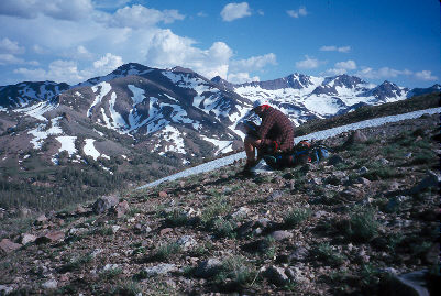
The sky on the climb up to Saint Mary's pass was a spectacular blue, but much of my attention was devoted to my feet. The blister on my right heel had been getting steadily worse as the trip wore on and it seemed that no amount of attention was helping it. Eventually I found that it was best to just put nothing on it.
The climb along the lively Clark Fork was exhausting (and amusing). We finally turned into the head of the canyon where the trees were lighter and the trail even lighter still. After the tread completely disappeared, there were many two-rock cairns to follow, sometimes so many that it was difficult to determine which ones to follow. We tried to stay to the south and took a more direct route up the canyon than the recommended guidebook route (the guidebook's route didn't look fun).
We finished the relentless affair by climbing up into unbroken snow slopes, where I broke out the ice axe, and finally reached Saint Mary's Pass. Uhh, actually we never really knew where we were. The pass isn't very obvious and the guidebook description and map just didn't jibe with our surroundings. However, we could tell where we wanted to go next with or without the guidebook's help. We struck out on a southerly compass' bearing and headed straight down a moderately steep canyon. After such an arduous climb, I was surprising nimble and balanced. We hit pavement right when we figured on hitting it and even to the east of where the guidebook would have dropped us out.
Back to the road. We'd already put in a hard 17 mile day and now we got to finish it off with a road walk. This walk was downhill for eight miles on a road with moderate traffic so it would have been relatively easy to hitch a ride. But Dave and I are both purists when it comes to completing an unbroken path on our hikes, so we didn't stick out our thumbs. I left Dave in the dust and fairly flew down the road. Five miles later when we reached Chipmunk Flat, a roadside parking lot with a little camping, our legs were Jell-O.
The rushing water of Deadman Creek sang us to sleep.
<Yesterday - Home - Tomorrow>
)
)
)
)
)
)
)
)
)